Tuesday, September 26, 2017

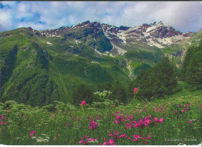
Western Caucasus


The Western Caucasus, extending over 275,000 ha of the extreme western end of the Caucasus mountains and located 50 km north-east of the Black Sea, is one of the few large mountain areas of Europe that has not experienced significant human impact. Its subalpine and alpine pastures have only been grazed by wild animals, and its extensive tracts of undisturbed mountain forests, extending from the lowlands to the subalpine zone, are unique in Europe. The site has a great diversity of ecosystems, with important endemic plants and wildlife, and is the place of origin and reintroduction of the mountain subspecies of the European bison.

Krasnodar Region
N44 0 0 E40 0 0
Date of Inscription: 1999
Criteria: (ix)(x)
Property : 298,903 ha
Ref: 900

Architectural Ensemble of the Trinity Sergius Lavra in Sergiev Posad


This is a fine example of a working Orthodox monastery, with military features that are typical of the 15th to the 18th century, the period during which it developed. The main church of the Lavra, the Cathedral of the Assumption (echoing the Kremlin Cathedral of the same name), contains the tomb of Boris Godunov. Among the treasures of the Lavra is the famous icon, The Trinity , by Andrei Rublev.

Moscow region, town Sergiev-Posad (ex Zagorsk)
N56 18 37.26 E38 7 52.32
Date of Inscription: 1993
Criteria: (ii)(iv)
Property : 22.75 ha
Buffer zone: 15.57 ha
Ref: 657

Lednice-Valtice Cultural Landscape


Between the 17th and 20th centuries, the ruling dukes of Liechtenstein transformed their domains in southern Moravia into a striking landscape. It married Baroque architecture (mainly the work of Johann Bernhard Fischer von Erlach) and the classical and neo-Gothic style of the castles of Lednice and Valtice with countryside fashioned according to English romantic principles of landscape architecture. At 200 km2 , it is one of the largest artificial landscapes in Europe.

Breclav District, South Moravian Region
N48 46 32.988 E16 46 30
Date of Inscription: 1996
Criteria: (i)(ii)(iv)
Property : 14,320 ha
Ref: 763

Olympic National Park


Located in the north-west of Washington State, Olympic National Park is renowned for the diversity of its ecosystems. Glacier-clad peaks interspersed with extensive alpine meadows are surrounded by an extensive old growth forest, among which is the best example of intact and protected temperate rainforest in the Pacific Northwest. Eleven major river systems drain the Olympic mountains, offering some of the best habitat for anadromous fish species in the country. The park also includes 100 km of wilderness coastline, the longest undeveloped coast in the contiguous United States, and is rich in native and endemic animal and plant species, including critical populations of the endangered northern spotted owl, marbled murrelet and bull trout.

State of Washington
N47 44 54 W123 26 56
Date of Inscription: 1981
Criteria: (vii)(ix)
Ref: 151

Caves of Aggtelek Karst and Slovak Karst


The variety of formations and the fact that they are concentrated in a restricted area means that the 712 caves currently identified make up a typical temperate-zone karstic system. Because they display an extremely rare combination of tropical and glacial climatic effects, they make it possible to study geological history over tens of millions of years.

Districts of Rožnava and Spišská Nová Ves, Region of Košice (SK)
N48 28 32.628 E20 29 12.732
Date of Inscription: 1995
Extension: 2000
Minor boundary modification inscribed year: 2008
Criteria: (viii)
Property : 56,650.57 ha
Buffer zone: 86,797.33 ha
Ref: 725ter

Temple Zone of Sambor Prei Kuk, Archaeological Site of Ancient Ishanapura


The archaeological site of Sambor Prei Kuk, “the temple in the richness of the forest” in the Khmer language, has been identified as Ishanapura, the capital of the Chenla Empire that flourished in the late 6th and early 7th centuries AD. The vestiges of the city cover an area of 25 sq km and include a walled city centre as well as numerous temples, ten of which are octagonal, unique specimens of their genre in South-East Asia. Decorated sandstone elements in the site are characteristic of the pre-Angkor decorative idiom, known as the Sambor Prei Kuk Style. Some of these elements, including lintels, pediments and colonnades, are true masterpieces. The art and architecture developed here became models for other parts of the region and lay the ground for the unique Khmer style of the Angkor period.

N12 52 21 E105 2 10
Date of Inscription: 2017
Criteria: (ii)(iii)(vi)
Ref: 1532

Temple of Preah Vihear


Situated on the edge of a plateau that dominates the plain of Cambodia, the Temple of Preah Vihear is dedicated to Shiva. The Temple is composed of a series of sanctuaries linked by a system of pavements and staircases over an 800 metre long axis and dates back to the first half of the 11th century AD. Nevertheless, its complex history can be traced to the 9th century, when the hermitage was founded. This site is particularly well preserved, mainly due to its remote location. The site is exceptional for the quality of its architecture, which is adapted to the natural environment and the religious function of the temple, as well as for the exceptional quality of its carved stone ornamentation.

N14 23 18 E104 41 2
Date of Inscription: 2008
Criteria: (i)
Property : 154.7 ha
Buffer zone: 2,642.5 ha
Ref: 1224rev

Khangchendzonga National Park


Located at the heart of the Himalayan range in northern India (State of Sikkim), the Khangchendzonga National Park includes a unique diversity of plains, valleys, lakes, glaciers and spectacular, snow-capped mountains covered with ancient forests, including the world’s third highest peak, Mount Khangchendzonga. Mythological stories are associated with this mountain and with a great number of natural elements (caves, rivers, lakes, etc.) that are the object of worship by the indigenous people of Sikkim. The sacred meanings of these stories and practices have been integrated with Buddhist beliefs and constitute the basis for Sikkimese identity.

N27 45 53 E88 22 38
Date of Inscription: 2016
Criteria: (iii)(vi)(vii)(x)
Property : 178,400 ha
Buffer zone: 114,712 ha
Ref: 1513

Taos Pueblo


Situated in the valley of a small tributary of the Rio Grande, this adobe settlement – consisting of dwellings and ceremonial buildings – represents the culture of the Pueblo Indians of Arizona and New Mexico.

New Mexico
N36 26 20.004 W105 32 30.012
Date of Inscription: 1992
Criteria: (iv)
Property : 19.01 ha
Ref: 492rev

Mount Hamiguitan Range Wildlife Sanctuary


Mount Hamiguitan Range Wildlife Sanctuary
Forming a mountain ridge running north-south along the Pujada Peninsula in the south-eastern part of the Eastern Mindanao Biodiversity Corridor, the Mount Hamiguitan Range Wildlife Sanctuary has an elevation range of 75–1,637 m above sea level and provides critical habitat for a range of plant and animal species. The property showcases terrestrial and aquatic habitats at different elevations, and includes threatened and endemic flora and fauna species, eight of which are found only at Mount Hamiguitan. These include critically endangered trees, plants and the iconic Philippine eagle and Philippine cockatoo.

N6 43 1.81 E126 10 24.35
Date of Inscription: 2014
Criteria: (x)
Property : 16,923.07 ha
Buffer zone: 9,729.77 ha
Ref: 1403rev

Monumental Earthworks of Poverty Point


Monumental Earthworks of Poverty Point
Monumental Earthworks of Poverty Point owes its name to a 19th-century plantation close to the site, which is in the Lower Mississippi Valley on a slightly elevated and narrow landform. The complex comprises five mounds, six concentric semi-elliptical ridges separated by shallow depressions and a central plaza. It was created and used for residential and ceremonial purposes by a society of hunter fisher-gatherers between 3700 and 3100 BP. It is a remarkable achievement in earthen construction in North America that was unsurpassed for at least 2,000 years.

N32 38 13 W91 24 23
Date of Inscription: 2014
Criteria: (iii)
Property : 163 ha
Ref: 1435

Mesa Verde National Park


Mesa Verde National Park
A great concentration of ancestral Pueblo Indian dwellings, built from the 6th to the 12th century, can be found on the Mesa Verde plateau in south-west Colorado at an altitude of more than 2,600 m. Some 4,400 sites have been recorded, including villages built on the Mesa top. There are also imposing cliff dwellings, built of stone and comprising more than 100 rooms.

Colorado
N37 15 42 W108 29 8
Date of Inscription: 1978
Criteria: (iii)
Property : 21,043 ha
Ref: 27

Papahānaumokuākea


Papahānaumokuākea
Papahānaumokuākea is a vast and isolated linear cluster of small, low lying islands and atolls, with their surrounding ocean, roughly 250 km to the northwest of the main Hawaiian Archipelago and extending over some 1931 km. The area has deep cosmological and traditional significance for living Native Hawaiian culture, as an ancestral environment, as an embodiment of the Hawaiian concept of kinship between people and the natural world, and as the place where it is believed that life originates and to where the spirits return after death. On two of the islands, Nihoa and Makumanamana, there are archaeological remains relating to pre-European settlement and use. Much of the monument is made up of pelagic and deepwater habitats, with notable features such as seamounts and submerged banks, extensive coral reefs and lagoons. It is one of the largest marine protected areas (MPAs) in the world.

N25 20 56.652 W170 8 44.952
Date of Inscription: 2010
Property : 36,207,499 ha
Ref: 1326

University of Coimbra – Alta and Sofia


University of Coimbra – Alta and Sofia
Situated on a hill overlooking the city, the University of Coimbra with its colleges grew and evolved over more than seven centuries within the old town. Notable university buildings include the 12th century Cathedral of Santa Cruz and a number of 16th century colleges,  the Royal Palace of Alcáçova, which has housed the University since 1537, the Joanine Library with its rich baroque decor, the 18th century Botanical Garden and University Press, as well as the large “University City” created during the 1940s. The University’s edifices became a reference in the development of other institutions of higher education in the Portuguese-speaking world where it also exerted a major influence on learning and literature. Coimbra offers an outstanding example of an integrated university city with a specific urban typology as well as its own ceremonial and cultural traditions that have been kept alive through the ages.

N40 12 28.12 W8 25 32.79
Date of Inscription: 2013
Criteria: (ii)(iv)(vi)
Property : 35.5 ha
Buffer zone: 81.5 ha
Ref: 1387

Historic Centre of Oporto, Luiz I Bridge and Monastery of Serra do Pilar


Historic Centre of Oporto, Luiz I Bridge and Monastery of Serra do Pilar
The city of Oporto, built along the hillsides overlooking the mouth of the Douro river, is an outstanding urban landscape with a 2,000-year history. Its continuous growth, linked to the sea (the Romans gave it the name Portus, or port), can be seen in the many and varied monuments, from the cathedral with its Romanesque choir, to the neoclassical Stock Exchange and the typically Portuguese Manueline-style Church of Santa Clara.

Northern region
N41 8 30 W8 37 0
Date of Inscription: 1996
Criteria: (iv)
Ref: 755

Historic City of Toledo


Historic City of Toledo
Successively a Roman municipium, the capital of the Visigothic Kingdom, a fortress of the Emirate of Cordoba, an outpost of the Christian kingdoms fighting the Moors and, in the 16th century, the temporary seat of supreme power under Charles V, Toledo is the repository of more than 2,000 years of history. Its masterpieces are the product of heterogeneous civilizations in an environment where the existence of three major religions – Judaism, Christianity and Islam – was a major factor.

Province of Toledo, Autonomous Community of Castile-La Mancha
N39 52 0.8 W4 1 45.9
Date of Inscription: 1986
Criteria: (i)(ii)(iii)(iv)
Property : 259.85 ha
Buffer zone: 7,669.28 ha
Ref: 379

Palau de la Música Catalana and Hospital de Sant Pau, Barcelona


Palau de la Música Catalana and Hospital de Sant Pau, Barcelona
These are two of the finest contributions to Barcelona's architecture by the Catalan art nouveau architect Lluís Domènech i Montaner. The Palau de la Música Catalana is an exuberant steel-framed structure full of light and space, and decorated by many of the leading designers of the day. The Hospital de Sant Pau is equally bold in its design and decoration, while at the same time perfectly adapted to the needs of the sick.

Province of Barcelona, Autonomous Community of Catalonia
N41 23 16.008 E2 10 30
Date of Inscription: 1997
Minor boundary modification inscribed year: 2008
Criteria: (i)(ii)(iv)
Ref: 804bis